GPS Reading Learning Objectives
After completing this section you should be able to:
- Explain basics of the Global Positioning Satellite (GPS) system
- Set the appropriate GPS coordinate systems
- Define common GPS Terms
- Explain the various GPS coordinate systems
- Set and use a Waypoint
- Set and use a Route
GPS Basics
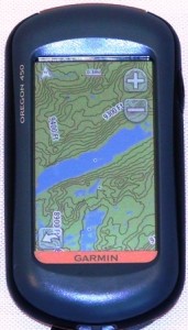
The part of the GPS system most familiar to us is the “receiver”. It’s primary purpose is to figure out with as much precision as possible where the heck we are. It may also have features to determine directions to our destination, and maybe even how long it will take to get there. Navigational GPS receivers may be built into a car, a boat, or an airplane. For adventures, the receiver is most likely to be a small hand held device like the one shown.
The GPS device depends on being able to “receive” radio signals from multiple satellites.
GSP Satellites

The GPS system is a collection of orbiting satellites. Which ones are actually visible from our location is constantly changing, but the overlapping orbits are designed such that there are always enough to pinpoint our location.
How does Trilateration work?
The satellites orbiting the earth are GPS transmitters. They do not know any more about your GPS receiver than a radio station knows about your car stereo. They just blindly send out a signal and it is up to you to have a device that can figure out what to do with the message. And just like your car stereo never sends a signal back to the radio station, your GPS device never communicates back to the satellite. It’s a one way conversation. Because of this, once you purchase your GPS you are good to go. You never have to pay any kind of subscription or license fee to receive these always available US Government provided signals.
Each always-transmitting satellite provides your receiver the information necessary to calculate the distance from it (and presumably you) to the satellite. The primary ingredient is time, and it requires very accurate clocks to pull it off. The actual algorithm and error corrections techniques are complicated and not of particular value to this training. However, an admittedly over simplified understanding will make clear how many satellites we need to make it work, and what external factors can confuse the calculation.
Train Me
Imagine a train, traveling at a constant and known speed, arrives at your station with a message telling you what time it left. Assuming your clock is in sync with the clock at the other station, you now know two of the three variables in DISTANCE = SPEED* TIME. Knowing the speed of the train, and how long it took to get to you, you can figure out how far away the other station is.
Our GPS device knows the speed a radio signal travels, and since it knows how long it took to get here, it can calculate the distance to the satellite. Well, actually back to where the satelite was at that known point of time in its known orbit. The fact that the satellite “train stations” are themselves moving around on a known path makes the calculation work for the GPS more complicated, but does not affect our time-tells-us-distance logic.
So how does knowing the distance to a satellite help?
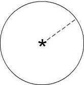
Let’s assume you are lost, and want to tell a rescuer where you are. If you know how far you are from a particular object, you have now narrowed your rescuer’s search to a circle whose radius is equal to your distance from that object.
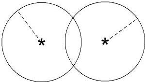
If you also know your distance to another known object, you now have two circles. When these two circles intersect, they make two points of contact. You have now narrowed your rescuer’s search to the two intersection points of the circles.
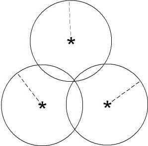
If you add a third known distance, you now have three circles. The common intersection of these three circles is a single point. Or pretty close to a single point based on the margin of error.
So in a two-dimensional world, if you know your distance from three known objects, you can figure out your location on that two-dimensional plane.
Three-Dimensions
As outdoor enthusiasts, however, we operate in a three dimensional world. We deal not only with longitude and latitude, but also altitude. In this three-dimensional world, and first known distance does not narrow our location to a two-dimensional circle, but rather a three-dimensional sphere. The second location then provides us with another sphere, and when two spheres intersect, they create a circle. Continuing with the same logic as before, we eventually get to a single point, but it takes known distances to 4 satellites, rather than 3, to do it.
Datum WGS84
Another factor in calculating location on Earth is the baseline earth surface. In other words, what is the baseline for earth’s “sea level”. WGS is the World Geodetic System and the Datum WGS84 was created in 1984 to define this baseline. Updated in 2004, it is still commonly used in most GPS systems today.
So what can mess it up?
As we have seen, you need concurrent lines of sight to multiple satellites for three-dimensional calculation. Things that disrupt our lines of sight may interfere with the receivers ability to figure out where we are. Being deep in a canyon or under heavy tree cover can throw it off.
At some point you may have noticed a car GSP losing signal completely, like when you are traveling deep in a parking garage. In that case, there is not enough satellite signals to calculate anything, so the GPS gives up and lets you know: Unable to acquire satellite signal, or some such message. Okay, that’s a bummer, but at least you know what is going on. Have you ever been traveling in a car with a GPS, perhaps in a mountainous area, and the GPS showed you traveling off the highway, even though you were pretty darn sure you were still safely on it? That’s a problem. The GPS thinks it has the data to accurately calculate where you are, but boy is it wrong. What’s going on?
If you remember we are calculating our location using the time the signal took to travel to us. If we are in areas where signals can be bounced around or otherwise delayed, the GPS will still receive them, but calculate our position to be somewhere other than where we actually are. Location is where we actually are; position fix is where the GPS calculates we are. To decrease the difference between location and position fix, we should look out for a few things.
- Make sure you have strong batteries in the device, and enough spares for the trip.
- Make sure the GPS you purchase has a high quality antenna.
- Pay attention to the signal strength of the satellites you can “see.” Stronger is better.
- Before drawing conclusions wait until you have more than the minimum required satellites locked on.
- Pay attention to your surroundings. If you are in a canyon, under tree cover or heavy atmospheric interference, your results should be treated as suspect.
- For more critical measurement, change positions until you have clear line of site to multiple satellites.
Set the Appropriate Coordinate System
Some GPS devices will give you various coordinate system options, but almost all will default to longitude and latitude. Before you jump in, you should make sure you understand the position format. Longitude and Latitude can be given in:
- degrees, minutes, and seconds (dd mm ss.s)
- degrees and minutes expressed in decimal (dd mm.mmm)
- degrees represented completely in decimal (ddd.ddddd)
In other words, the exact same location (in this case Mt Rushmore) could be expressed in these three ways:
- 43° 52′ 49” N; 103° 27′ 33” W
- 42° 52.8166666′ N; 103° 27.55′ W
- 43.880278° N, -103.459167° W
Mistaking one format to the other can create serious errors. 27.55′ is not the same as 27′ 55”
Common GPS Terms
Waypoint
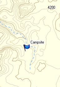
A waypoint is nothing more than a location coordinate stored in the GPS.
In some cases a waypoint represents a location you have not yet navigated to. Some GPS units come pre-loaded with popular locations and some allow you to import waypoints from other systems. You can can also enter a waypoint manually by looking up the desired position (perhaps in Google Earth or from Topo maps) and entering it directly into your GPS. Remember to make sure the coordinate systems of the map source matches the coordinate system of your GPS.
At other times you will want to store your current location so you can easily return to it, such as the location of the your car at the trailhead, that awesome camp site, or that easy kayak takeout. In these case you do not need to enter the coordinates manually, the GPS already knows where you are. You simply need to save the current location as a waypoint.
GOTO:
Most GPS units have a GOTO function. You are telling the GPS which of the many waypoints in the database is the one you want to navigate to. Once selected, the GSP can provide direction guidance to that location, though typically in a straight line, or “as the crow files.” If you are not a crow, you probably will not be able to follow a straight line to your destination. The good news is the GPS knows where you are, and will keep correcting to point you toward the destination, no matter how you approach it. Some newer mapping GPSs may have trail information which can be used for turn by turn directions. If you are traveling great distances, you will probably want to break up your trip in to a connected series of waypoints, rather than just one straight line across the entire wilderness.
Route:
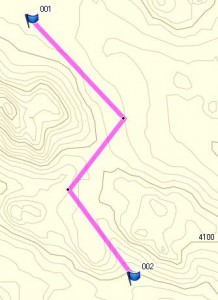
A route is an ordered list of stored waypoints. In other words, it is a list of the places you want to go, in the order you intend to visit them. During planning you probably talk to friends, read articles and websites, and examine maps to determine the most logical route. The decisions you make, on trail and off, will be reflected in the order and location of the waypoints you create. Some people using compatible systems will share favorite routes with each other.
Track:
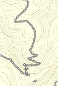
A track is sort of the opposite of a route. Instead of a list of points you want to visit, it is an automatically created list of the places you have actually been. Depending on what you encounter in the field, the track you create and save will not necessarily be the same as the route you attempted to follow. Many GPS units will allow you to take a saved track and reverse it to create a route back the way you came.
WAAS (Wide Area Augmentation System)
Augmentation is a process to improve GSP accuracy by including other data information. WASS improves the accuracy of your GPS by gathering correction information from ground stations, and retransmitting it to GPS receivers from stationary satellites (not the same as the 24 orbiting ones). WAAS capable receivers can improve accuracy by including this information when calculating location. This works best in open area, and has proven not very effective in heavy ground cover such as wilderness forests.
GPS Purchase Considerations:
When purchasing a GPS for backpacking, you should consider the following features:
- Size and Weight (small but useful screen)
- Battery Life (color and electronic compass can significantly deplete)
- Available Topo Maps (for purchase and freeware)
- Antenna Quality (critical for wilderness)
- WAAS capable (nice, but less critical in wilderness)
- Readable in daylight, night
- User Interface (touch screen, buttons)
- Cost
Review:
You should be able to:
- Explain basics of the Global Positioning Satellite (GPS) system
- Set the appropriate GPS coordinate systems
- Define common GPS Terms
- Explain the various GPS coordinate systems
- Set and use a Waypoint
- Set and use a Route
